


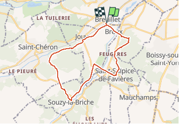
Entre l’Orge et la renarde

Arnaud Stévenard
User

Length
14.6 km

Max alt
153 m

Uphill gradient
275 m
Km-Effort
18.3 km

Min alt
56 m

Downhill gradient
275 m
Boucle
Yes
Creation date :
2020-09-12 07:38:40.0
Updated on :
2020-09-12 11:11:10.293
3h32
Difficulty : Unknown

FREE GPS app for hiking
 SityTrail
IGN / Geographical institutes
SityTrail Plus
The world is yours!
About
Trail Walking of 14.6 km to be discovered at Ile-de-France, Essonne, Breuillet. This trail is proposed by Arnaud Stévenard.
Positioning
Country:
France
Region :
Ile-de-France
Department/Province :
Essonne
Municipality :
Breuillet
Location:
Unknown
Start:(Dec)
Start:(UTM)
438944 ; 5379447 (31U) N.
Comments