


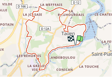
Autour de Taden

selevrich
User

Length
11.2 km

Max alt
72 m

Uphill gradient
172 m
Km-Effort
13.4 km

Min alt
6 m

Downhill gradient
170 m
Boucle
Yes
Creation date :
2020-09-12 13:10:13.514
Updated on :
2020-09-12 13:16:40.351
--
Difficulty : Easy

FREE GPS app for hiking
 SityTrail
IGN / Geographical institutes
SityTrail Plus
The world is yours!
About
Trail On foot of 11.2 km to be discovered at Brittany, Côtes-d'Armor, Taden. This trail is proposed by selevrich.
Description
circuit varié sans difficultés. Découverte du chemin de halage qui longe la Rance entre Dinan et Taden.
Positioning
Country:
France
Region :
Brittany
Department/Province :
Côtes-d'Armor
Municipality :
Taden
Location:
Unknown
Start:(Dec)
Start:(UTM)
573005 ; 5369087 (30U) N.
Comments