


Marigny du 12/09/2020

VANDERPUTTENMi
User GUIDE
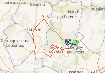

Length
14.3 km

Max alt
208 m

Uphill gradient
306 m
Km-Effort
18.3 km

Min alt
89 m

Downhill gradient
307 m
Boucle
Yes
Creation date :
2020-09-12 12:26:03.636
Updated on :
2020-09-12 19:37:55.369
1h20
Difficulty : Very easy

FREE GPS app for hiking
 SityTrail
IGN / Geographical institutes
SityTrail Plus
The world is yours!
About
Trail Mountain bike of 14.3 km to be discovered at Hauts-de-France, Aisne, Marigny-en-Orxois. This trail is proposed by VANDERPUTTENMi.
Description
chemin entre Gandelu et Marigny en végétation..difficile d'accès !!
Positioning
Country:
France
Region :
Hauts-de-France
Department/Province :
Aisne
Municipality :
Marigny-en-Orxois
Location:
Unknown
Start:(Dec)
Start:(UTM)
516419 ; 5434129 (31U) N.
Comments