


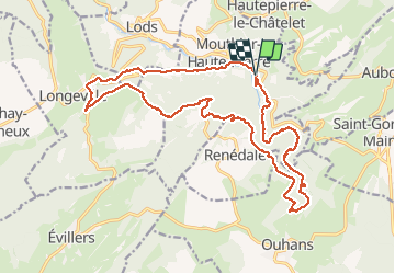
Source de la Loue

LaurentGILG
User

Length
22 km

Max alt
861 m

Uphill gradient
759 m
Km-Effort
32 km

Min alt
377 m

Downhill gradient
761 m
Boucle
Yes
Creation date :
2020-09-12 07:33:16.007
Updated on :
2020-09-12 14:54:56.382
5h00
Difficulty : Difficult

FREE GPS app for hiking
 SityTrail
IGN / Geographical institutes
SityTrail Plus
The world is yours!
About
Trail Walking of 22 km to be discovered at Bourgogne-Franche-Comté, Doubs, Mouthier-Haute-Pierre. This trail is proposed by LaurentGILG.
Positioning
Country:
France
Region :
Bourgogne-Franche-Comté
Department/Province :
Doubs
Municipality :
Mouthier-Haute-Pierre
Location:
Unknown
Start:(Dec)
Start:(UTM)
293640 ; 5212641 (32T) N.
Comments