


Château-Thierry de Places en Places

VANDERPUTTENMi
User GUIDE
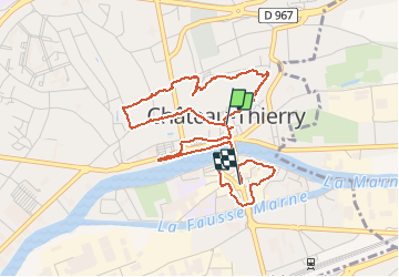

Length
4.7 km

Max alt
100 m

Uphill gradient
57 m
Km-Effort
5.5 km

Min alt
56 m

Downhill gradient
60 m
Boucle
No
Creation date :
2020-09-13 07:30:57.939
Updated on :
2020-09-13 13:54:32.354
1h40
Difficulty : Very easy

FREE GPS app for hiking
 SityTrail
IGN / Geographical institutes
SityTrail Plus
The world is yours!
About
Trail Walking of 4.7 km to be discovered at Hauts-de-France, Aisne, Château-Thierry. This trail is proposed by VANDERPUTTENMi.
Photos

Positioning
Country:
France
Region :
Hauts-de-France
Department/Province :
Aisne
Municipality :
Château-Thierry
Location:
Unknown
Start:(Dec)
Start:(UTM)
529430 ; 5432563 (31U) N.
Comments