


Cascades et Volcans

GOHIER
User
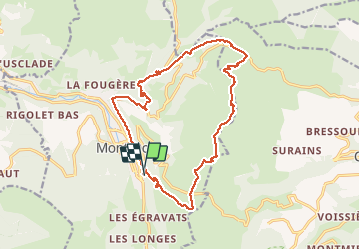

Length
18.7 km

Max alt
1727 m

Uphill gradient
911 m
Km-Effort
31 km

Min alt
1056 m

Downhill gradient
914 m
Boucle
Yes
Creation date :
2020-09-13 07:55:44.0
Updated on :
2020-09-13 16:12:30.332
8h11
Difficulty : Unknown

FREE GPS app for hiking
 SityTrail
IGN / Geographical institutes
SityTrail Plus
The world is yours!
About
Trail Walking of 18.7 km to be discovered at Auvergne-Rhône-Alpes, Puy-de-Dôme, Mont-Dore. This trail is proposed by GOHIER.
Description
Boucle à Patou. Bien éprouvant
Positioning
Country:
France
Region :
Auvergne-Rhône-Alpes
Department/Province :
Puy-de-Dôme
Municipality :
Mont-Dore
Location:
Unknown
Start:(Dec)
Start:(UTM)
485544 ; 5046136 (31T) N.
Comments