


st Jean tous

guy07
User
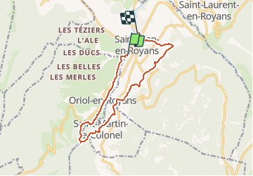

Length
12.9 km

Max alt
363 m

Uphill gradient
296 m
Km-Effort
16.9 km

Min alt
238 m

Downhill gradient
292 m
Boucle
No
Creation date :
2020-09-15 07:26:36.659
Updated on :
2020-09-16 07:02:57.413
4h52
Difficulty : Very easy

FREE GPS app for hiking
 SityTrail
IGN / Geographical institutes
SityTrail Plus
The world is yours!
About
Trail Walking of 12.9 km to be discovered at Auvergne-Rhône-Alpes, Drôme, Saint-Jean-en-Royans. This trail is proposed by guy07.
Positioning
Country:
France
Region :
Auvergne-Rhône-Alpes
Department/Province :
Drôme
Municipality :
Saint-Jean-en-Royans
Location:
Unknown
Start:(Dec)
Start:(UTM)
680133 ; 4986864 (31T) N.
Comments