


Corronsac lac de Montbrun fait

pidjam
User
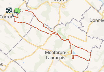

Length
11 km

Max alt
281 m

Uphill gradient
224 m
Km-Effort
14 km

Min alt
193 m

Downhill gradient
223 m
Boucle
Yes
Creation date :
2020-09-17 06:58:04.557
Updated on :
2020-09-17 09:59:05.717
3h00
Difficulty : Medium

FREE GPS app for hiking
 SityTrail
IGN / Geographical institutes
SityTrail Plus
The world is yours!
About
Trail Walking of 11 km to be discovered at Occitania, Haute-Garonne, Corronsac. This trail is proposed by pidjam.
Positioning
Country:
France
Region :
Occitania
Department/Province :
Haute-Garonne
Municipality :
Corronsac
Location:
Unknown
Start:(Dec)
Start:(UTM)
378487 ; 4814463 (31T) N.
Comments