


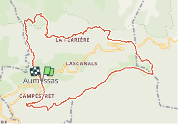
Aumessas - Col de Mouzoules par les Venedes et le Caladon

philcll
User

Length
14.2 km

Max alt
965 m

Uphill gradient
793 m
Km-Effort
25 km

Min alt
431 m

Downhill gradient
793 m
Boucle
Yes
Creation date :
2020-09-17 07:07:35.884
Updated on :
2020-09-17 18:56:43.689
5h24
Difficulty : Medium

FREE GPS app for hiking
 SityTrail
IGN / Geographical institutes
SityTrail Plus
The world is yours!
About
Trail Walking of 14.2 km to be discovered at Occitania, Gard, Aumessas. This trail is proposed by philcll.
Description
retour par les Crêtes du Colombier et rocher du Comte
Positioning
Country:
France
Region :
Occitania
Department/Province :
Gard
Municipality :
Aumessas
Location:
Unknown
Start:(Dec)
Start:(UTM)
540429 ; 4870969 (31T) N.
Comments