


Les Écrins lac des Fétoules refuge de la Lavey

c.gourme
User
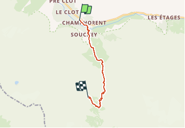

Length
9.2 km

Max alt
2352 m

Uphill gradient
930 m
Km-Effort
21 km

Min alt
1429 m

Downhill gradient
682 m
Boucle
No
Creation date :
2020-09-15 08:34:08.0
Updated on :
2020-09-18 12:34:34.873
6h06
Difficulty : Medium

FREE GPS app for hiking
 SityTrail
IGN / Geographical institutes
SityTrail Plus
The world is yours!
About
Trail Walking of 9.2 km to be discovered at Auvergne-Rhône-Alpes, Isère, Saint-Christophe-en-Oisans. This trail is proposed by c.gourme.
Description
Beau point de vue au lac belle descente au refuge. Pour revenir au parking depuis le refuge rajouter 1h40
Positioning
Country:
France
Region :
Auvergne-Rhône-Alpes
Department/Province :
Isère
Municipality :
Saint-Christophe-en-Oisans
Location:
Unknown
Start:(Dec)
Start:(UTM)
279065 ; 4979591 (32T) N.
Comments