


depart rouffange ..abbaye d'acey et 6 villages de haute saone

gerardmicheline
User
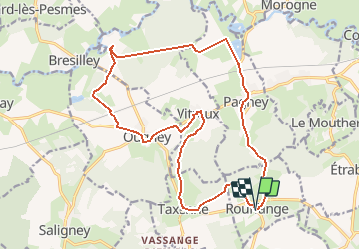

Length
19.5 km

Max alt
341 m

Uphill gradient
412 m
Km-Effort
25 km

Min alt
191 m

Downhill gradient
418 m
Boucle
Yes
Creation date :
2020-09-18 15:29:38.656
Updated on :
2020-09-18 15:31:42.088
5h21
Difficulty : Very difficult

FREE GPS app for hiking
 SityTrail
IGN / Geographical institutes
SityTrail Plus
The world is yours!
About
Trail Walking of 19.5 km to be discovered at Bourgogne-Franche-Comté, Jura, Rouffange. This trail is proposed by gerardmicheline.
Positioning
Country:
France
Region :
Bourgogne-Franche-Comté
Department/Province :
Jura
Municipality :
Rouffange
Location:
Unknown
Start:(Dec)
Start:(UTM)
704829 ; 5233601 (31T) N.
Comments