


romo menetou romo

mimilolo
User
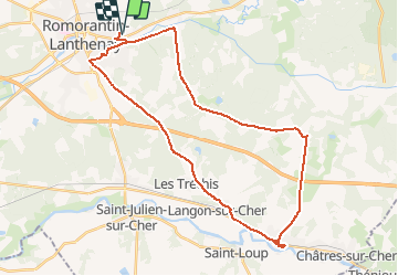

Length
36 km

Max alt
132 m

Uphill gradient
297 m
Km-Effort
40 km

Min alt
86 m

Downhill gradient
298 m
Boucle
Yes
Creation date :
2020-09-19 06:53:49.049
Updated on :
2020-09-19 06:57:14.413
2h00
Difficulty : Very easy

FREE GPS app for hiking
 SityTrail
IGN / Geographical institutes
SityTrail Plus
The world is yours!
About
Trail Cycle of 36 km to be discovered at Centre-Loire Valley, Loir-et-Cher, Romorantin-Lanthenay. This trail is proposed by mimilolo.

Positioning
Country:
France
Region :
Centre-Loire Valley
Department/Province :
Loir-et-Cher
Municipality :
Romorantin-Lanthenay
Location:
Unknown
Start:(Dec)
Start:(UTM)
407026 ; 5245727 (31T) N.
Comments