


port pin

Bwattier
User

Length
2.8 km

Max alt
57 m

Uphill gradient
91 m
Km-Effort
4 km

Min alt
6 m

Downhill gradient
86 m
Boucle
No
Creation date :
2020-09-19 09:23:47.841
Updated on :
2020-09-19 10:17:49.575
53m
Difficulty : Very easy

FREE GPS app for hiking
 SityTrail
IGN / Geographical institutes
SityTrail Plus
The world is yours!
About
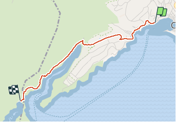
Trail Walking of 2.8 km to be discovered at Provence-Alpes-Côte d'Azur, Bouches-du-Rhône, Cassis. This trail is proposed by Bwattier.
Positioning
Country:
France
Region :
Provence-Alpes-Côte d'Azur
Department/Province :
Bouches-du-Rhône
Municipality :
Cassis
Location:
Unknown
Start:(Dec)
Start:(UTM)
705880 ; 4787731 (31T) N.
Comments