


Fontainebleau

mg.carpentier
User
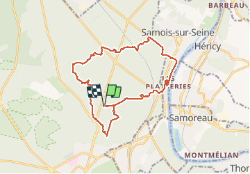

Length
17.2 km

Max alt
158 m

Uphill gradient
233 m
Km-Effort
20 km

Min alt
47 m

Downhill gradient
232 m
Boucle
Yes
Creation date :
2020-09-19 07:47:57.333
Updated on :
2020-09-19 13:37:49.994
4h59
Difficulty : Very easy

FREE GPS app for hiking
 SityTrail
IGN / Geographical institutes
SityTrail Plus
The world is yours!
About
Trail Walking of 17.2 km to be discovered at Ile-de-France, Seine-et-Marne, Fontainebleau. This trail is proposed by mg.carpentier.
Positioning
Country:
France
Region :
Ile-de-France
Department/Province :
Seine-et-Marne
Municipality :
Fontainebleau
Location:
Unknown
Start:(Dec)
Start:(UTM)
478796 ; 5364054 (31U) N.
Comments