


montherme4.2020.09.19

trusgnachjf
User
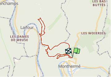

Length
18.5 km

Max alt
375 m

Uphill gradient
629 m
Km-Effort
27 km

Min alt
131 m

Downhill gradient
631 m
Boucle
Yes
Creation date :
2020-09-19 07:33:05.109
Updated on :
2020-09-19 15:36:37.441
8h01
Difficulty : Very easy

FREE GPS app for hiking
 SityTrail
IGN / Geographical institutes
SityTrail Plus
The world is yours!
About
Trail Walking of 18.5 km to be discovered at Grand Est, Ardennes, Monthermé. This trail is proposed by trusgnachjf.
Positioning
Country:
France
Region :
Grand Est
Department/Province :
Ardennes
Municipality :
Monthermé
Location:
Unknown
Start:(Dec)
Start:(UTM)
625171 ; 5527899 (31U) N.
Comments