


saint leu

pmauvieux
User
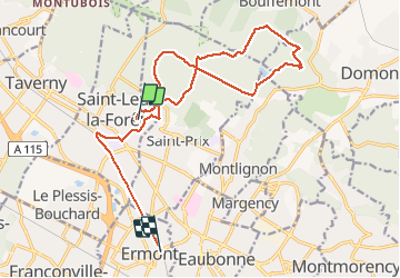

Length
17.2 km

Max alt
193 m

Uphill gradient
347 m
Km-Effort
22 km

Min alt
53 m

Downhill gradient
402 m
Boucle
No
Creation date :
2020-09-20 06:41:18.875
Updated on :
2020-09-20 10:40:13.501
3h33
Difficulty : Very easy

FREE GPS app for hiking
 SityTrail
IGN / Geographical institutes
SityTrail Plus
The world is yours!
About
Trail Walking of 17.2 km to be discovered at Ile-de-France, Val-d'Oise, Saint-Leu-la-Forêt. This trail is proposed by pmauvieux.
Positioning
Country:
France
Region :
Ile-de-France
Department/Province :
Val-d'Oise
Municipality :
Saint-Leu-la-Forêt
Location:
Unknown
Start:(Dec)
Start:(UTM)
445566 ; 5429832 (31U) N.
Comments