


la Pinede
© OpenStreetMap contributors


1h33
Difficulty : Very easy


Length
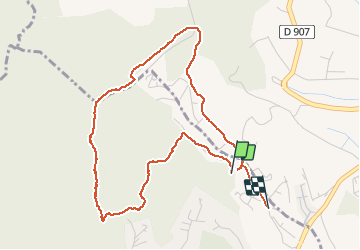
5 km
Max alt
617 m
Uphill gradient
160 m
Km-Effort
7.2 km
Min alt
421 m
Downhill gradient
192 m
Boucle
No
Creation date :
2020-09-21 07:12:20.814
Updated on :
2020-09-21 11:20:44.785
1h33
Difficulty : Very easy
FREE GPS app for hiking
 SityTrail
IGN / Geographical institutes
SityTrail Plus
The world is yours!
About
Trail Walking of 5 km to be discovered at Provence-Alpes-Côte d'Azur, Alpes-de-Haute-Provence, Pierrevert. This trail is proposed by Jean-Denis-Danielle Mauduit.
Description
Depart vers les poubelles en haut de la rue de la Pinède
Positioning
Country:
France
Region :
Provence-Alpes-Côte d'Azur
Department/Province :
Alpes-de-Haute-Provence
Municipality :
Pierrevert
Location:
Unknown
Start:(Dec)
Start:(UTM)
720857 ; 4856533 (31T) N.
Comments