


16/08/2020 - BESLE.Variante jusque Langon.Virtuel

babeth35
User
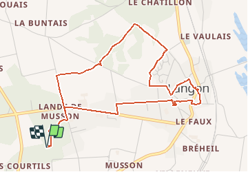

Length
5.5 km

Max alt
56 m

Uphill gradient
67 m
Km-Effort
6.4 km

Min alt
12 m

Downhill gradient
67 m
Boucle
Yes
Creation date :
2020-09-21 12:20:14.782
Updated on :
2020-09-21 12:38:10.674
--
Difficulty : Medium
1h24
Difficulty : Medium

FREE GPS app for hiking
 SityTrail
IGN / Geographical institutes
SityTrail Plus
The world is yours!
About
Trail On foot of 5.5 km to be discovered at Brittany, Ille-et-Vilaine, Langon. This trail is proposed by babeth35.
Positioning
Country:
France
Region :
Brittany
Department/Province :
Ille-et-Vilaine
Municipality :
Langon
Location:
Unknown
Start:(Dec)
Start:(UTM)
584932 ; 5285302 (30T) N.
Comments