


2020-09-22_07h47m46_Trigance Rougon

gerardmicheline
User
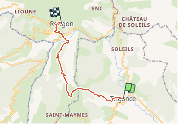

Length
10.3 km

Max alt
1156 m

Uphill gradient
723 m
Km-Effort
19.3 km

Min alt
624 m

Downhill gradient
537 m
Boucle
No
Creation date :
2020-09-22 05:47:46.224
Updated on :
2020-09-22 05:47:48.085

FREE GPS app for hiking
 SityTrail
IGN / Geographical institutes
SityTrail Plus
The world is yours!
About
Trail of 10.3 km to be discovered at Provence-Alpes-Côte d'Azur, Var, Trigance. This trail is proposed by gerardmicheline.
Positioning
Country:
France
Region :
Provence-Alpes-Côte d'Azur
Department/Province :
Var
Municipality :
Trigance
Location:
Unknown
Start:(Dec)
Start:(UTM)
294358 ; 4848522 (32T) N.
Comments