


Pt de Meyzieu- ouest 22 09 20- 6.5a 36 g 0.3 d 15

jtraverse
User
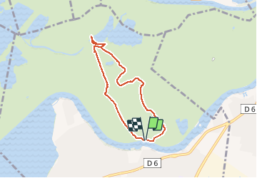


2h10
Difficulty : Very easy

FREE GPS app for hiking
 SityTrail
IGN / Geographical institutes
SityTrail Plus
The world is yours!
About
Trail Walking of 6.5 km to be discovered at Auvergne-Rhône-Alpes, Métropole de Lyon, Meyzieu. This trail is proposed by jtraverse.
Description
GL10-GL11-GL12 Pont de Meyzieu-Trajet voiture 14.5km – 17minutes voiture
GPS Pk : 45°47'14.7"N 5°00'35.3"E ou 45.787429, 5.009814
Adresse parking 5 La Garenne 69330 Meyzieu
Direction Rocade Est direction PARIS -Décines-Charpieu, jusqu’à la sortie 6, Puis à gauche (Chemin des Grands Lacs) direction Pont de Meyzieu. Traverser le pont, se garer à gauche ou à droite au bout du pont
Positioning
Comments
Promenade simple dans la parc de Miribel à deux pas de Lyon.