


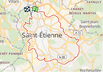
Voie Verte St Etienne VTTAE

psesjs
User

Length
22 km

Max alt
646 m

Uphill gradient
515 m
Km-Effort
29 km

Min alt
484 m

Downhill gradient
512 m
Boucle
Yes
Creation date :
2020-09-23 07:59:44.703
Updated on :
2020-09-23 10:11:58.854
1h31
Difficulty : Medium

FREE GPS app for hiking
 SityTrail
IGN / Geographical institutes
SityTrail Plus
The world is yours!
About
Trail Mountain bike of 22 km to be discovered at Auvergne-Rhône-Alpes, Loire, Saint-Étienne. This trail is proposed by psesjs.
Positioning
Country:
France
Region :
Auvergne-Rhône-Alpes
Department/Province :
Loire
Municipality :
Saint-Étienne
Location:
Unknown
Start:(Dec)
Start:(UTM)
607470 ; 5034581 (31T) N.
Comments