


Citadelle !

michelcortvrint
User
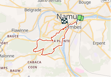

Length
12.4 km

Max alt
222 m

Uphill gradient
345 m
Km-Effort
17 km

Min alt
72 m

Downhill gradient
351 m
Boucle
No
Creation date :
2020-09-23 08:12:48.0
Updated on :
2020-09-23 12:02:16.777
3h04
Difficulty : Very easy

FREE GPS app for hiking
 SityTrail
IGN / Geographical institutes
SityTrail Plus
The world is yours!
About
Trail Walking of 12.4 km to be discovered at Wallonia, Namur, Namur. This trail is proposed by michelcortvrint.
Positioning
Country:
Belgium
Region :
Wallonia
Department/Province :
Namur
Municipality :
Namur
Location:
Jambes
Start:(Dec)
Start:(UTM)
633113 ; 5591484 (31U) N.
Comments