


Plan du Lion

jlrayon
User
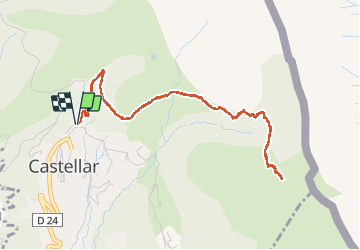

Length
5.6 km

Max alt
729 m

Uphill gradient
399 m
Km-Effort
11 km

Min alt
339 m

Downhill gradient
400 m
Boucle
Yes
Creation date :
2020-09-23 08:06:54.587
Updated on :
2020-09-28 15:17:38.088
2h47
Difficulty : Medium

FREE GPS app for hiking
 SityTrail
IGN / Geographical institutes
SityTrail Plus
The world is yours!
About
Trail Walking of 5.6 km to be discovered at Provence-Alpes-Côte d'Azur, Maritime Alps, Castellar. This trail is proposed by jlrayon.
Positioning
Country:
France
Region :
Provence-Alpes-Côte d'Azur
Department/Province :
Maritime Alps
Municipality :
Castellar
Location:
Unknown
Start:(Dec)
Start:(UTM)
379203 ; 4851500 (32T) N.
Comments