


St Raphaël 10km 20200923

cmike39
User
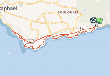

Length
10.5 km

Max alt
24 m

Uphill gradient
102 m
Km-Effort
11.8 km

Min alt
0 m

Downhill gradient
95 m
Boucle
Yes
Creation date :
2020-09-23 11:58:46.783
Updated on :
2020-09-23 15:42:26.096
2h51
Difficulty : Very easy

FREE GPS app for hiking
 SityTrail
IGN / Geographical institutes
SityTrail Plus
The world is yours!
About
Trail Walking of 10.5 km to be discovered at Provence-Alpes-Côte d'Azur, Var, Saint-Raphaël. This trail is proposed by cmike39.
Positioning
Country:
France
Region :
Provence-Alpes-Côte d'Azur
Department/Province :
Var
Municipality :
Saint-Raphaël
Location:
Unknown
Start:(Dec)
Start:(UTM)
323730 ; 4809485 (32T) N.
Comments