


St Mitre les Remparts - les étangs

mhetpierre
User
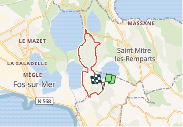

Length
10.8 km

Max alt
61 m

Uphill gradient
168 m
Km-Effort
13.1 km

Min alt
-3 m

Downhill gradient
166 m
Boucle
Yes
Creation date :
2020-09-24 13:28:22.246
Updated on :
2021-03-05 20:23:04.125
3h35
Difficulty : Difficult

FREE GPS app for hiking
 SityTrail
IGN / Geographical institutes
SityTrail Plus
The world is yours!
About
Trail Walking of 10.8 km to be discovered at Provence-Alpes-Côte d'Azur, Bouches-du-Rhône, Port-de-Bouc. This trail is proposed by mhetpierre.
Positioning
Country:
France
Region :
Provence-Alpes-Côte d'Azur
Department/Province :
Bouches-du-Rhône
Municipality :
Port-de-Bouc
Location:
Unknown
Start:(Dec)
Start:(UTM)
661263 ; 4811058 (31T) N.
Comments