


Sancey

tiene
User
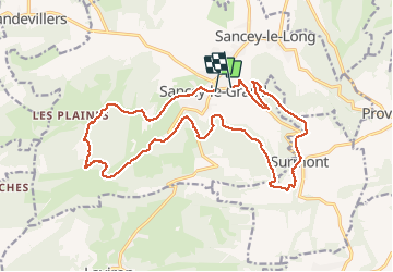

Length
19.4 km

Max alt
732 m

Uphill gradient
557 m
Km-Effort
27 km

Min alt
494 m

Downhill gradient
569 m
Boucle
No
Creation date :
2020-09-24 06:57:26.679
Updated on :
2020-09-25 06:47:22.628
5h51
Difficulty : Medium

FREE GPS app for hiking
 SityTrail
IGN / Geographical institutes
SityTrail Plus
The world is yours!
About
Trail Walking of 19.4 km to be discovered at Bourgogne-Franche-Comté, Doubs, Sancey. This trail is proposed by tiene.
Positioning
Country:
France
Region :
Bourgogne-Franche-Comté
Department/Province :
Doubs
Municipality :
Sancey
Location:
Unknown
Start:(Dec)
Start:(UTM)
317318 ; 5240692 (32T) N.
Comments