


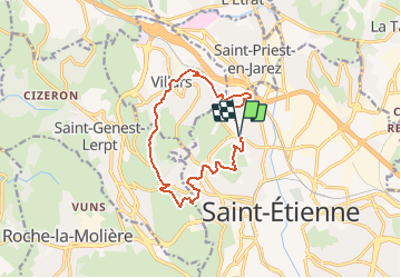
Saint E Balades 14 VTTAE Villars Côte Chaude

psesjs
User

Length
12.7 km

Max alt
640 m

Uphill gradient
371 m
Km-Effort
17.6 km

Min alt
466 m

Downhill gradient
368 m
Boucle
Yes
Creation date :
2020-09-24 14:28:54.186
Updated on :
2020-09-24 16:16:58.893
3h43
Difficulty : Medium
1h12
Difficulty : Medium

FREE GPS app for hiking
 SityTrail
IGN / Geographical institutes
SityTrail Plus
The world is yours!
About
Trail Walking of 12.7 km to be discovered at Auvergne-Rhône-Alpes, Loire, Saint-Étienne. This trail is proposed by psesjs.
Positioning
Country:
France
Region :
Auvergne-Rhône-Alpes
Department/Province :
Loire
Municipality :
Saint-Étienne
Location:
Unknown
Start:(Dec)
Start:(UTM)
607471 ; 5034588 (31T) N.
Comments