


Upen d'Aval 12,5Kms (Dén P 278m)

alain62rando
User
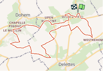

Length
12.5 km

Max alt
144 m

Uphill gradient
278 m
Km-Effort
16.2 km

Min alt
49 m

Downhill gradient
279 m
Boucle
Yes
Creation date :
2020-09-27 16:46:29.42
Updated on :
2020-09-27 16:48:01.41
3h27
Difficulty : Medium

FREE GPS app for hiking
 SityTrail
IGN / Geographical institutes
SityTrail Plus
The world is yours!
About
Trail Walking of 12.5 km to be discovered at Hauts-de-France, Pas-de-Calais, Delettes. This trail is proposed by alain62rando.
Positioning
Country:
France
Region :
Hauts-de-France
Department/Province :
Pas-de-Calais
Municipality :
Delettes
Location:
Unknown
Start:(Dec)
Start:(UTM)
444842 ; 5609909 (31U) N.
Comments