


Cap Esterel_Rastel d'Agay 13km D+ 420m 20200927

cmike39
User
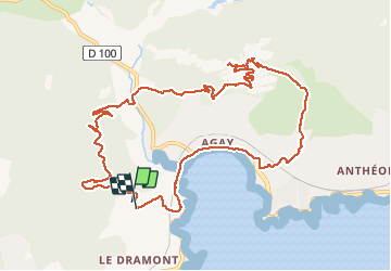

Length
12.7 km

Max alt
273 m

Uphill gradient
394 m
Km-Effort
17.9 km

Min alt
0 m

Downhill gradient
382 m
Boucle
Yes
Creation date :
2020-09-27 12:53:38.024
Updated on :
2020-09-27 16:57:29.501
3h06
Difficulty : Very easy

FREE GPS app for hiking
 SityTrail
IGN / Geographical institutes
SityTrail Plus
The world is yours!
About
Trail Walking of 12.7 km to be discovered at Provence-Alpes-Côte d'Azur, Var, Saint-Raphaël. This trail is proposed by cmike39.
Positioning
Country:
France
Region :
Provence-Alpes-Côte d'Azur
Department/Province :
Var
Municipality :
Saint-Raphaël
Location:
Unknown
Start:(Dec)
Start:(UTM)
325934 ; 4810588 (32T) N.
Comments