


st jalle

Joel26400
User
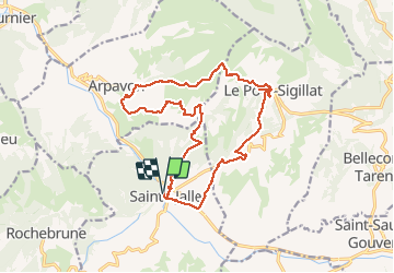

Length
18.8 km

Max alt
801 m

Uphill gradient
602 m
Km-Effort
27 km

Min alt
402 m

Downhill gradient
600 m
Boucle
Yes
Creation date :
2020-09-27 07:16:29.131
Updated on :
2020-09-28 06:36:10.319
6h40
Difficulty : Medium

FREE GPS app for hiking
 SityTrail
IGN / Geographical institutes
SityTrail Plus
The world is yours!
About
Trail Walking of 18.8 km to be discovered at Auvergne-Rhône-Alpes, Drôme, Sainte-Jalle. This trail is proposed by Joel26400.
Description
vallonnée
Positioning
Country:
France
Region :
Auvergne-Rhône-Alpes
Department/Province :
Drôme
Municipality :
Sainte-Jalle
Location:
Unknown
Start:(Dec)
Start:(UTM)
681945 ; 4912829 (31T) N.
Comments