


St-Urcize : bourg et station

cron
User
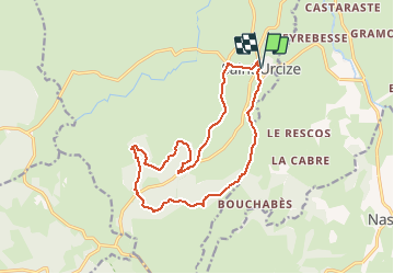

Length
15.6 km

Max alt
1362 m

Uphill gradient
377 m
Km-Effort
21 km

Min alt
1090 m

Downhill gradient
376 m
Boucle
Yes
Creation date :
2020-09-28 15:38:35.533
Updated on :
2020-09-28 15:39:54.486
4h00
Difficulty : Medium

FREE GPS app for hiking
 SityTrail
IGN / Geographical institutes
SityTrail Plus
The world is yours!
About
Trail Walking of 15.6 km to be discovered at Auvergne-Rhône-Alpes, Cantal, Saint-Urcize. This trail is proposed by cron.
Positioning
Country:
France
Region :
Auvergne-Rhône-Alpes
Department/Province :
Cantal
Municipality :
Saint-Urcize
Location:
Unknown
Start:(Dec)
Start:(UTM)
500233 ; 4949219 (31T) N.
Comments