


tisane CALAMANTE

Jacky Fumey
User
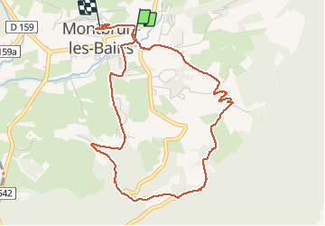

Length
5.2 km

Max alt
738 m

Uphill gradient
168 m
Km-Effort
7.4 km

Min alt
594 m

Downhill gradient
138 m
Boucle
No
Creation date :
2020-09-29 07:07:46.909
Updated on :
2020-09-29 09:24:51.986
2h15
Difficulty : Easy

FREE GPS app for hiking
 SityTrail
IGN / Geographical institutes
SityTrail Plus
The world is yours!
About
Trail Walking of 5.2 km to be discovered at Auvergne-Rhône-Alpes, Drôme, Montbrun-les-Bains. This trail is proposed by Jacky Fumey.
Positioning
Country:
France
Region :
Auvergne-Rhône-Alpes
Department/Province :
Drôme
Municipality :
Montbrun-les-Bains
Location:
Unknown
Start:(Dec)
Start:(UTM)
695417 ; 4894239 (31T) N.
Comments