


Laguiole - Le Bousquet

cron
User
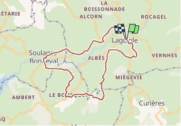

Length
18.6 km

Max alt
1045 m

Uphill gradient
433 m
Km-Effort
24 km

Min alt
849 m

Downhill gradient
433 m
Boucle
Yes
Creation date :
2020-09-29 10:33:40.754
Updated on :
2020-09-29 10:34:46.773
5h00
Difficulty : Difficult

FREE GPS app for hiking
 SityTrail
IGN / Geographical institutes
SityTrail Plus
The world is yours!
About
Trail Walking of 18.6 km to be discovered at Occitania, Aveyron, Laguiole. This trail is proposed by cron.
Description
départ : parking centre Laguiole
Positioning
Country:
France
Region :
Occitania
Department/Province :
Aveyron
Municipality :
Laguiole
Location:
Unknown
Start:(Dec)
Start:(UTM)
487955 ; 4947843 (31T) N.
Comments