


La Gache

Franz BOFFARD
User

Length
19.3 km

Max alt
180 m

Uphill gradient
436 m
Km-Effort
25 km

Min alt
9 m

Downhill gradient
436 m
Boucle
Yes
Creation date :
2020-09-30 06:32:32.0
Updated on :
2020-09-30 09:24:55.444
2h52
Difficulty : Medium

FREE GPS app for hiking
 SityTrail
IGN / Geographical institutes
SityTrail Plus
The world is yours!
About
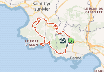
Trail Mountain bike of 19.3 km to be discovered at Provence-Alpes-Côte d'Azur, Var, Bandol. This trail is proposed by Franz BOFFARD.
Positioning
Country:
France
Region :
Provence-Alpes-Côte d'Azur
Department/Province :
Var
Municipality :
Bandol
Location:
Unknown
Start:(Dec)
Start:(UTM)
722900 ; 4780601 (31T) N.
Comments