


montherme5.2020.09.30

trusgnachjf
User
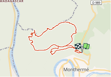

Length
10.6 km

Max alt
375 m

Uphill gradient
355 m
Km-Effort
15.3 km

Min alt
160 m

Downhill gradient
354 m
Boucle
Yes
Creation date :
2020-09-30 07:38:37.604
Updated on :
2020-09-30 10:55:32.149
3h15
Difficulty : Very easy

FREE GPS app for hiking
 SityTrail
IGN / Geographical institutes
SityTrail Plus
The world is yours!
About
Trail Walking of 10.6 km to be discovered at Grand Est, Ardennes, Monthermé. This trail is proposed by trusgnachjf.
Positioning
Country:
France
Region :
Grand Est
Department/Province :
Ardennes
Municipality :
Monthermé
Location:
Unknown
Start:(Dec)
Start:(UTM)
625167 ; 5527876 (31U) N.
Comments