


pont du gard Jean

MichelBughin
User
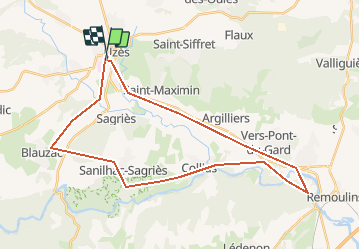

Length
36 km

Max alt
180 m

Uphill gradient
626 m
Km-Effort
45 km

Min alt
16 m

Downhill gradient
623 m
Boucle
Yes
Creation date :
2020-09-30 11:34:19.272
Updated on :
2020-09-30 16:45:21.792
4h02
Difficulty : Very easy

FREE GPS app for hiking
 SityTrail
IGN / Geographical institutes
SityTrail Plus
The world is yours!
About
Trail Mountain bike of 36 km to be discovered at Occitania, Gard, Uzès. This trail is proposed by MichelBughin.
Positioning
Country:
France
Region :
Occitania
Department/Province :
Gard
Municipality :
Uzès
Location:
Unknown
Start:(Dec)
Start:(UTM)
613244 ; 4873737 (31T) N.
Comments