


Pic de l'Ours 15 km 20200930

cmike39
User
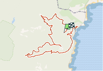

Length
13.2 km

Max alt
486 m

Uphill gradient
467 m
Km-Effort
19.8 km

Min alt
9 m

Downhill gradient
585 m
Boucle
No
Creation date :
2020-09-30 11:45:59.958
Updated on :
2020-09-30 17:38:58.459
3h25
Difficulty : Very easy

FREE GPS app for hiking
 SityTrail
IGN / Geographical institutes
SityTrail Plus
The world is yours!
About
Trail Walking of 13.2 km to be discovered at Provence-Alpes-Côte d'Azur, Var, Saint-Raphaël. This trail is proposed by cmike39.
Positioning
Country:
France
Region :
Provence-Alpes-Côte d'Azur
Department/Province :
Var
Municipality :
Saint-Raphaël
Location:
Unknown
Start:(Dec)
Start:(UTM)
331484 ; 4815338 (32T) N.
Comments