


2020-10-01_07h15m53_E16

LUTZMarc
User
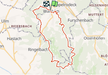

Length
17.6 km

Max alt
658 m

Uphill gradient
685 m
Km-Effort
27 km

Min alt
211 m

Downhill gradient
697 m
Boucle
Yes
Creation date :
2020-10-01 05:15:54.23
Updated on :
2020-10-29 19:20:02.884
5h34
Difficulty : Medium

FREE GPS app for hiking
 SityTrail
IGN / Geographical institutes
SityTrail Plus
The world is yours!
About
Trail Walking of 17.6 km to be discovered at Baden-Württemberg, Ortenaukreis, Kappelrodeck. This trail is proposed by LUTZMarc.
Description
circuit tres agreable avec quelques montés assez exigentes.
Resto Zum Fiesemichel
Positioning
Country:
Germany
Region :
Baden-Württemberg
Department/Province :
Ortenaukreis
Municipality :
Kappelrodeck
Location:
Unknown
Start:(Dec)
Start:(UTM)
433781 ; 5381941 (32U) N.
Comments