


Aix en Provence -Bibemus - Zola - Bimont

mhetpierre
User
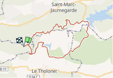

Length
10.4 km

Max alt
374 m

Uphill gradient
269 m
Km-Effort
14 km

Min alt
222 m

Downhill gradient
270 m
Boucle
Yes
Creation date :
2020-10-01 09:25:38.325
Updated on :
2020-10-15 10:46:26.766
--
Difficulty : Very easy

FREE GPS app for hiking
 SityTrail
IGN / Geographical institutes
SityTrail Plus
The world is yours!
About
Trail On foot of 10.4 km to be discovered at Provence-Alpes-Côte d'Azur, Bouches-du-Rhône, Aix-en-Provence. This trail is proposed by mhetpierre.
Positioning
Country:
France
Region :
Provence-Alpes-Côte d'Azur
Department/Province :
Bouches-du-Rhône
Municipality :
Aix-en-Provence
Location:
Unknown
Start:(Dec)
Start:(UTM)
702085 ; 4822861 (31T) N.
Comments