


12105277-Fontaine Simon 18.38

togolo28
User
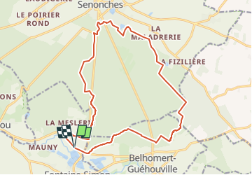

Length
18.3 km

Max alt
289 m

Uphill gradient
223 m
Km-Effort
21 km

Min alt
196 m

Downhill gradient
223 m
Boucle
Yes
Creation date :
2020-10-01 16:34:39.053
Updated on :
2023-03-30 09:36:35.084
4h49
Difficulty : Very difficult

FREE GPS app for hiking
 SityTrail
IGN / Geographical institutes
SityTrail Plus
The world is yours!
About
Trail Walking of 18.3 km to be discovered at Centre-Loire Valley, Eure-et-Loir, Fontaine-Simon. This trail is proposed by togolo28.
Positioning
Country:
France
Region :
Centre-Loire Valley
Department/Province :
Eure-et-Loir
Municipality :
Fontaine-Simon
Location:
Unknown
Start:(Dec)
Start:(UTM)
353742 ; 5375224 (31U) N.
Comments