


Les hauts de valcros

Chapatann
User
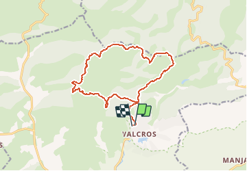

Length
16.8 km

Max alt
434 m

Uphill gradient
609 m
Km-Effort
25 km

Min alt
83 m

Downhill gradient
608 m
Boucle
Yes
Creation date :
2014-12-10 00:00:00.0
Updated on :
2014-12-10 00:00:00.0
5h00
Difficulty : Unknown

FREE GPS app for hiking
 SityTrail
IGN / Geographical institutes
SityTrail Plus
The world is yours!
About
Trail Other activity of 16.8 km to be discovered at Provence-Alpes-Côte d'Azur, Var, La Londe-les-Maures. This trail is proposed by Chapatann.
Positioning
Country:
France
Region :
Provence-Alpes-Côte d'Azur
Department/Province :
Var
Municipality :
La Londe-les-Maures
Location:
Unknown
Start:(Dec)
Start:(UTM)
277809 ; 4783836 (32T) N.
Comments