


tavel

mopingon
User
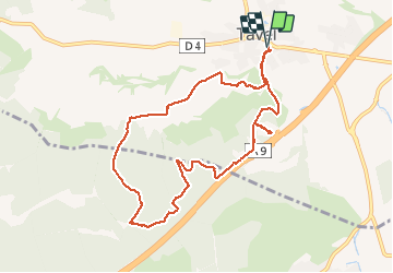

Length
9.8 km

Max alt
197 m

Uphill gradient
182 m
Km-Effort
12.2 km

Min alt
100 m

Downhill gradient
182 m
Boucle
Yes
Creation date :
2020-10-01 11:54:33.109
Updated on :
2020-10-02 04:39:21.269
3h01
Difficulty : Medium

FREE GPS app for hiking
 SityTrail
IGN / Geographical institutes
SityTrail Plus
The world is yours!
About
Trail Walking of 9.8 km to be discovered at Occitania, Gard, Tavel. This trail is proposed by mopingon.
Description
randonnée
Positioning
Country:
France
Region :
Occitania
Department/Province :
Gard
Municipality :
Tavel
Location:
Unknown
Start:(Dec)
Start:(UTM)
636260 ; 4874532 (31T) N.
Comments