Trail Walking Nesselwang - Nesselwang Alpspitz - Photo
© OpenStreetMap contributors
Length
Length
10.8 km
Max alt
Max alt
1560 m
Uphill gradient
Uphill gradient
617 m
Km-Effort
Km-Effort  
19.2 km
Min alt
Min alt
889 m
Downhill gradient
Downhill gradient
681 m
Boucle
Boucle
No
Creation date :
2020-10-03 07:48:06.257
Updated on :
2020-10-03 12:32:35.675

(0 Reviews)

Walking
Walking
3h30
Difficulty : Medium

Scan this QR Code to open this trail in the SityTrail application

FREE GPS app for hiking

Logo SityTrail SityTrail

IGN / Geographical institutes

Download SityTrail from the App Store Download SityTrail from Google Play

Logo SityTrail SityTrail World

The world is yours!

Download SityTrail from the App Store Download SityTrail from Google Play Download SityTrail on Huawei AppGallery

About

Trail Walking of 10.8 km to be discovered at Bavaria, Landkreis Ostallgäu, Nesselwang. This trail is proposed by fissettemichel.

Description

montée raide beaucoup escaliers métalliques difficiles pour les chiens..retour facile

Elevation profile

Positioning

Country:
Germany
Region :
Bavaria
Department/Province :
Landkreis Ostallgäu
Municipality :
Nesselwang
Location:
Unknown
Start:(UTM)
613018 ; 5274577 (32T) N.

Trails nearby

Trail On foot Jungholz - Jungholz - lokale Wanderwege - Photo
On foot
PRO

On foot

Easy
Jungholz, Tyrol, Bezirk Reutte, Austria
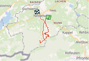
3.8 km | 7.8 km-effort
1h 46min
No
Trail On foot Nesselwang - Nesselwang - lokale beschilderte Wanderwege - Photo
On foot
PRO

On foot

Easy
Nesselwang, Bavaria, Landkreis Ostallgäu, Germany
5.6 km | 6.8 km-effort
1h 33min
No
Trail On foot Oy-Mittelberg - Steinmeile - Photo
On foot
PRO

On foot

Easy
Oy-Mittelberg, Bavaria, Landkreis Oberallgäu, Germany
8.2 km | 10.6 km-effort
2h 23min
Yes
Trail On foot Nesselwang - Ge(h)zeiten - Photo
On foot
PRO

On foot

Easy
Nesselwang, Bavaria, Landkreis Ostallgäu, Germany
3.1 km | 4 km-effort
54min
No


Close
My subscriptions