
Appeville Annebault

Roulland
User
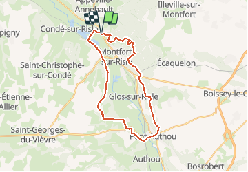

Length
26 km

Max alt
148 m

Uphill gradient
510 m
Km-Effort
33 km

Min alt
26 m

Downhill gradient
511 m
Boucle
Yes
Creation date :
2020-10-03 07:46:59.991
Updated on :
2020-10-03 14:01:24.155
4h42
Difficulty : Medium

FREE GPS app for hiking
 SityTrail
IGN / Geographical institutes
SityTrail Plus
The world is yours!
About
Trail Walking of 26 km to be discovered at Normandy, Eure, Appeville-Annebault. This trail is proposed by Roulland.
Description
BELLE RANDO, PAS TROP DE GOUDRON, SAUF SUR LA FIN.
LE TEMPS INDIQUÉ NE TIENT PAS COMPTE DES PAUSES.
Photos


Positioning
Country:
France
Region :
Normandy
Department/Province :
Eure
Municipality :
Appeville-Annebault
Location:
Unknown
Start:(Dec)
Start:(UTM)
329101 ; 5464604 (31U) N.
Comments