


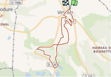
la voie du tram

raymondfn
User


2h24
Difficulty : Medium

FREE GPS app for hiking
 SityTrail
IGN / Geographical institutes
SityTrail Plus
The world is yours!
About
Trail Walking of 8.8 km to be discovered at Auvergne-Rhône-Alpes, Isère, Viriville. This trail is proposed by raymondfn.
Description
Cette balade emprunte en partie l'ancienne voie du tram qui reliait au début du 20ème siècle, Lyon à Saint-Marcellin.
Départ : près de l'ancienne gare de Viriville, aujourd'hui transformé en centre médical.
Positioning
Comments