Trail On foot Milly-la-Forêt - JC 12 - 13,8 km - Fontainebleau 100 et 150 marches - 18 km effort - Photo

JC 12 - 13,8 km - Fontainebleau 100 et 150 marches - 18 km effort

Club randonnées SERVON

© OpenStreetMap contributors
Length
Length
14.9 km
Max alt
Max alt
137 m
Uphill gradient
Uphill gradient
295 m
Km-Effort
Km-Effort  
18.8 km
Min alt
Min alt
72 m
Downhill gradient
Downhill gradient
295 m
Boucle
Boucle
Yes
Creation date :
2020-10-04 16:09:27.875
Updated on :
2024-01-24 13:50:24.209

(4 Reviews)

On foot
On foot
4h16
Difficulty : Difficult

Scan this QR Code to open this trail in the SityTrail application

FREE GPS app for hiking

Logo SityTrail SityTrail

IGN / Geographical institutes

Download SityTrail from the App Store Download SityTrail from Google Play

Logo SityTrail SityTrail World

The world is yours!

Download SityTrail from the App Store Download SityTrail from Google Play Download SityTrail on Huawei AppGallery

About

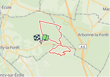
Trail On foot of 14.9 km to be discovered at Ile-de-France, Essonne, Milly-la-Forêt. This trail is proposed by Les 1000 pattes.

Description

Parcours passant par les 100 marches (qui sont 110) et finissant par les 145 marches le long de l'aqueduc. Marches  construites entre 1868 et 1874 pour la construction de l’Aqueduc en souterrain.

Parking Chemin de la Boulignère à Milly la Forêt
Trajet Servon-->Parking (55km: 38mn)
distance de Servon :  55 km
temps de trajet           :  38 minutes

Elevation profile

Points of interest

Point of interest Milly-la-Forêt - 150 marches - Photo
Marc Auger
MILLY-LA-FORÊT 
Point of interest Milly-la-Forêt - 100 marches - Photo
Marc Auger
MILLY-LA-FORÊT 
Point of interest Noisy-sur-École - Marches - Photo
Marc Auger
NOISY-SUR-ÉCOLE 

Positioning

Country:
France
Region :
Ile-de-France
Department/Province :
Essonne
Municipality :
Milly-la-Forêt
Location:
Unknown
Start:(UTM)
463604 ; 5361436 (31U) N.

Comments

Please log in to post a review or rate the element


Trails nearby

Trail Walking Le Vaudoué - Ultra 25 bosses - Photo
Walking
Aristotic

Walking

Difficult
(1)
Le Vaudoué, Ile-de-France, Seine-et-Marne, France
25 km | 32 km-effort
9h 2min
Yes
Trail Walking Noisy-sur-École - M&R-121118 - 250Marches - Photo
Walking
randodan

Walking

Easy
(1)
Noisy-sur-École, Ile-de-France, Seine-et-Marne, France
14.3 km | 18.1 km-effort
3h 50min
Yes
Trail Walking Milly-la-Forêt - Du parking de la Boulignère aux 100 marches via la ferme des Coquibus - Photo
Walking
philippebenne

Walking

Difficult
(1)
Milly-la-Forêt, Ile-de-France, Essonne, France
18.3 km | 22 km-effort
5h 0min
Yes
Trail Walking Noisy-sur-École - Bois Rond#4 - Photo
Walking
aubr

Walking

Very easy
(1)
Noisy-sur-École, Ile-de-France, Seine-et-Marne, France
8.8 km | 10.5 km-effort
2h 18min
Yes
Trail Walking Noisy-sur-École - Les 25 Bosses - Gps en Forêt de Fontainebleau - Photo
Walking
tracegps

Walking

Very difficult
(2)
Noisy-sur-École, Ile-de-France, Seine-et-Marne, France
17.6 km | 23 km-effort
4h 45min
Yes
Trail Walking Noisy-sur-École - Circuit 25 bosses Fontainebleau 14km - Photo
Walking
GUIDE
jeanmarcMasson

Walking

Difficult
(1)
Noisy-sur-École, Ile-de-France, Seine-et-Marne, France
14.2 km | 18.7 km-effort
4h 15min
Yes
Trail On foot Moigny-sur-École - Chemin des Grés et des Bruyères - Photo
On foot
PRO

On foot

Medium
Moigny-sur-École, Ile-de-France, Essonne, France
21 km | 24 km-effort
5h 23min
No
Trail Walking Milly-la-Forêt - pso-170525 - Coquibus-100marches - Photo
Walking
randodan

Walking

Medium
(1)
Milly-la-Forêt, Ile-de-France, Essonne, France
15.6 km | 19.3 km-effort
7h 0min
Yes
Trail Walking Noisy-sur-École - PSO-160824 - CancheMerciers-Belvédères - Photo
Walking
randodan

Walking

Medium
(2)
Noisy-sur-École, Ile-de-France, Seine-et-Marne, France
9.2 km | 11 km-effort
4h 0min
Yes


Close
My subscriptions