Herault - VTT - Meze le tour de l'Etang de Thau 62km 20m

RandoVal
User

Length
62 km

Max alt
24 m

Uphill gradient
430 m
Km-Effort
68 km

Min alt
-7 m

Downhill gradient
430 m
Boucle
Yes
Creation date :
2020-10-05 06:53:52.254
Updated on :
2020-10-05 06:54:43.159
--
Difficulty : Unknown

FREE GPS app for hiking
 SityTrail
IGN / Geographical institutes
SityTrail Plus
The world is yours!
About
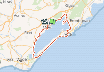
Trail Mountain bike of 62 km to be discovered at Occitania, Hérault, Mèze. This trail is proposed by RandoVal.
Description
Le tour de l’Étang de Thau au départ de Mèze, stationnement sur le parking des Tonneliers, sens anti-horaire. Petite balade dans Sète et la Point Courte, retour par la voie verte.
Positioning
Country:
France
Region :
Occitania
Department/Province :
Hérault
Municipality :
Mèze
Location:
Unknown
Start:(Dec)
Start:(UTM)
548967 ; 4807844 (31T) N.
Comments