


LONGEMER

surceneux
User

Length
10.5 km

Max alt
833 m

Uphill gradient
219 m
Km-Effort
13.5 km

Min alt
718 m

Downhill gradient
219 m
Boucle
Yes
Creation date :
2020-10-05 08:29:25.485
Updated on :
2020-10-05 11:51:38.432
1h50
Difficulty : Very easy

FREE GPS app for hiking
 SityTrail
IGN / Geographical institutes
SityTrail Plus
The world is yours!
About
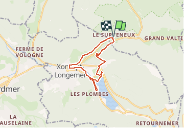
Trail Walking of 10.5 km to be discovered at Grand Est, Vosges, Ban-sur-Meurthe-Clefcy. This trail is proposed by surceneux.
Description
SURCENEUX LONGEMER RIVE DROITE BUTTE BILON AR VOIRIE MINICIPALE XONRUPT LES FIES SURCENEUX
Positioning
Country:
France
Region :
Grand Est
Department/Province :
Vosges
Municipality :
Ban-sur-Meurthe-Clefcy
Location:
Unknown
Start:(Dec)
Start:(UTM)
347834 ; 5329046 (32U) N.
Comments