


les rousses les montagnes les rousses

Dupleix
User
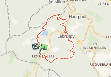

Length
17.9 km

Max alt
868 m

Uphill gradient
609 m
Km-Effort
26 km

Min alt
512 m

Downhill gradient
605 m
Boucle
Yes
Creation date :
2020-10-05 12:02:15.049
Updated on :
2020-10-05 12:03:18.958
--
Difficulty : Medium

FREE GPS app for hiking
 SityTrail
IGN / Geographical institutes
SityTrail Plus
The world is yours!
About
Trail On foot of 17.9 km to be discovered at Occitania, Tarn, Mazamet. This trail is proposed by Dupleix.
Positioning
Country:
France
Region :
Occitania
Department/Province :
Tarn
Municipality :
Mazamet
Location:
Unknown
Start:(Dec)
Start:(UTM)
446338 ; 4810530 (31T) N.
Comments