


2020-10-06_19h49m19_E1

LUTZMarc
User
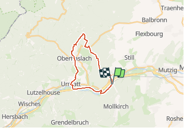

Length
19.4 km

Max alt
425 m

Uphill gradient
406 m
Km-Effort
25 km

Min alt
212 m

Downhill gradient
405 m
Boucle
Yes
Creation date :
2020-10-06 17:49:19.572
Updated on :
2020-10-29 19:12:57.221
5h20
Difficulty : Easy

FREE GPS app for hiking
 SityTrail
IGN / Geographical institutes
SityTrail Plus
The world is yours!
About
Trail Walking of 19.4 km to be discovered at Grand Est, Bas-Rhin, Mollkirch. This trail is proposed by LUTZMarc.
Description
Resto à Niederhaslach
Positioning
Country:
France
Region :
Grand Est
Department/Province :
Bas-Rhin
Municipality :
Mollkirch
Location:
Unknown
Start:(Dec)
Start:(UTM)
380498 ; 5376156 (32U) N.
Comments